![](/images/other/stat-length.png)
![Randonnée Marche La Chapelle-d'Abondance - SevanBraitazArvouin - Photo](https://media.geolcdn.com/t/1900/400/ext.pjpeg?maxdim=2&url=https%3A%2F%2Fservices.sitytrail.com%2FGeolivesWS%2FDownloadMedia.ashx%3FTrailID%3D306033%26Media%3Dfix__20140522111124.jpg)
SevanBraitazArvouin
helmut68
Utilisateur
![Longueur](/images/other/stat-length.png)
Longueur
8,1 km
![Altitude max](https://static1.geolcdn.com/siteimages/upload/files/1508320355ic_sort_altitude_max_24dp.png)
Altitude max
1897 m
![Dénivelé positif](https://static1.geolcdn.com/siteimages/upload/files/1508320355ic_sort_den_pos_24dp.png)
Dénivelé positif
378 m
![Km-Effort](/images/other/stat-length.png)
Km-Effort
13,1 km
![Altitude min](https://static1.geolcdn.com/siteimages/upload/files/1508320355ic_sort_altitude_min_24dp.png)
Altitude min
1586 m
![Dénivelé négatif](https://static1.geolcdn.com/siteimages/upload/files/1508320355ic_sort_den_neg_24dp.png)
Dénivelé négatif
376 m
![Boucle](https://static1.geolcdn.com/siteimages/upload/files/16400158638029165_repeat_loop_refresh_sync_direction_icon.png)
Boucle
Oui
Date de création :
2018-07-20 19:16:25.153
Dernière modification :
2018-07-20 19:16:25.153
![Marche](https://static1.geolcdn.com/sitytour/trail-icons/101.png)
2h57
Difficulté : Moyen
![Scannez ce code QR pour ouvrir la randonnée dans l'application SityTrail](https://capi.geolives.com/qq0zvz2zws4bq2lad0pu/sitytour/trails/306033/qr.png?size=200)
Application GPS de randonnée GRATUITE
À propos
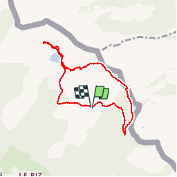
Randonnée Marche de 8,1 km à découvrir à Auvergne-Rhône-Alpes, Haute-Savoie, La Chapelle-d'Abondance. Cette randonnée est proposée par helmut68.
Description
Parcours facile et agréable jusqu'au col d' Outanne puos descente trés raide jusqu' au lac d'Arvouin ( être équipé ).
On est tombé sur un troupeau de jeunes bouquetins . . .
Localisation
Pays :
France
Région :
Auvergne-Rhône-Alpes
Département/Province :
Haute-Savoie
Commune :
La Chapelle-d'Abondance
Localité :
Unknown
Départ:(Dec)
Départ:(UTM)
332016 ; 5130321 (32T) N.
Commentaires
Randonnées à proximité
![Randonnée Marche La Chapelle-d'Abondance - Le Linleu 2093 m, depuis Sevan-devant - Photo](https://media.geolcdn.com/t/375/260/ext.jpg?maxdim=2&url=https%3A%2F%2Fservices.sitytrail.com%2FGeolivesWS%2FDownloadMedia.ashx%3FTrailID%3D215118%26Media%3D15702_1.jpg)
![Marche Marche](https://static1.geolcdn.com/sitytour/trail-icons/101.png)
Le Linleu 2093 m, depuis Sevan-devant
Marche
Moyen
(1)
La Chapelle-d'Abondance,
Auvergne-Rhône-Alpes,
Haute-Savoie,
France
![](/images/other/stat-length.png)
5,1 km | 11,9 km-effort
3h 0min
![](https://static1.geolcdn.com/siteimages/upload/files/16400158638029165_repeat_loop_refresh_sync_direction_icon.png)
Oui
![Randonnée Marche La Chapelle-d'Abondance - Les Cornettes de Bise par le sentier de Saix Rouquin - Photo](https://media.geolcdn.com/t/375/260/ext.jpg?maxdim=2&url=https%3A%2F%2Fservices.sitytrail.com%2FGeolivesWS%2FDownloadMedia.ashx%3FTrailID%3D107441%26Media%3D12359_1.jpg)
![Marche Marche](https://static1.geolcdn.com/sitytour/trail-icons/101.png)
Les Cornettes de Bise par le sentier de Saix Rouquin
Marche
Difficile
(1)
La Chapelle-d'Abondance,
Auvergne-Rhône-Alpes,
Haute-Savoie,
France
![](/images/other/stat-length.png)
10 km | 25 km-effort
6h 30min
![](https://static1.geolcdn.com/siteimages/upload/files/16400158638029165_repeat_loop_refresh_sync_direction_icon.png)
Oui
![Randonnée Marche La Chapelle-d'Abondance - Cascade boucle 2 - Photo](https://media.geolcdn.com/t/375/260/ext.jpg?maxdim=2&url=https%3A%2F%2Fstatic1.geolcdn.com%2Fsiteimages%2Fupload%2Ffiles%2F1553511878bg_sport_marche.png)
![Marche Marche](https://static1.geolcdn.com/sitytour/trail-icons/101.png)
Cascade boucle 2
Marche
Difficile
(1)
La Chapelle-d'Abondance,
Auvergne-Rhône-Alpes,
Haute-Savoie,
France
![](/images/other/stat-length.png)
10,1 km | 14,9 km-effort
3h 23min
![](https://static1.geolcdn.com/siteimages/upload/files/16400158638029165_repeat_loop_refresh_sync_direction_icon.png)
Oui
![Randonnée A pied Vouvry - Miex-Lac Tanay (via Prélagine) - Photo](https://media.geolcdn.com/t/375/260/c59c9fa1-00dd-4194-9bdd-60bf51ceb886.jpeg&format=jpg&maxdim=2)
![A pied A pied](https://static1.geolcdn.com/sitytour/trail-icons/100.png)
Miex-Lac Tanay (via Prélagine)
A pied
Facile
Vouvry,
Valais,
Monthey,
Suisse
![](/images/other/stat-length.png)
6,3 km | 9,9 km-effort
2h 15min
![](https://static1.geolcdn.com/siteimages/upload/files/16400158638029165_repeat_loop_refresh_sync_direction_icon.png)
Non
![Randonnée A pied Vionnaz - Torgon village - Chalet de Blancsex - Photo](https://media.geolcdn.com/t/375/260/d3e7664f-c0e4-4060-bc02-bdc516796cd2.jpeg&format=jpg&maxdim=2)
![A pied A pied](https://static1.geolcdn.com/sitytour/trail-icons/100.png)
Torgon village - Chalet de Blancsex
A pied
Facile
Vionnaz,
Valais,
Monthey,
Suisse
![](/images/other/stat-length.png)
4,4 km | 8,7 km-effort
1h 58min
![](https://static1.geolcdn.com/siteimages/upload/files/16400158638029165_repeat_loop_refresh_sync_direction_icon.png)
Non
![Randonnée A pied Vionnaz - Torgon village - Dravers - Photo](https://media.geolcdn.com/t/375/260/d3e7664f-c0e4-4060-bc02-bdc516796cd2.jpeg&format=jpg&maxdim=2)
![A pied A pied](https://static1.geolcdn.com/sitytour/trail-icons/100.png)
Torgon village - Dravers
A pied
Facile
Vionnaz,
Valais,
Monthey,
Suisse
![](/images/other/stat-length.png)
4 km | 8,3 km-effort
1h 53min
![](https://static1.geolcdn.com/siteimages/upload/files/16400158638029165_repeat_loop_refresh_sync_direction_icon.png)
Non
![Randonnée Raquettes à neige Châtel - Petite Châtel - Photo](https://media.geolcdn.com/t/375/260/ext.jpg?maxdim=2&url=https%3A%2F%2Fservices.sitytrail.com%2FGeolivesWS%2FDownloadMedia.ashx%3FTrailID%3D1119269%26Media%3Db7d0cc1f-c4ed-4071-ac32-dc424d2d5cb2.JPG)
![Raquettes à neige Raquettes à neige](https://static1.geolcdn.com/sitytour/trail-icons/504.png)
Petite Châtel
Raquettes à neige
Moyen
Châtel,
Auvergne-Rhône-Alpes,
Haute-Savoie,
France
![](/images/other/stat-length.png)
5,7 km | 10,6 km-effort
2h 0min
![](https://static1.geolcdn.com/siteimages/upload/files/16400158638029165_repeat_loop_refresh_sync_direction_icon.png)
Oui
![Randonnée Marche La Chapelle-d'Abondance - lac darbon - Photo](https://media.geolcdn.com/t/375/260/ext.jpg?maxdim=2&url=https%3A%2F%2Fstatic1.geolcdn.com%2Fsiteimages%2Fupload%2Ffiles%2F1553511878bg_sport_marche.png)
![Marche Marche](https://static1.geolcdn.com/sitytour/trail-icons/101.png)
lac darbon
Marche
Facile
(1)
La Chapelle-d'Abondance,
Auvergne-Rhône-Alpes,
Haute-Savoie,
France
![](/images/other/stat-length.png)
5,9 km | 13,7 km-effort
3h 54min
![](https://static1.geolcdn.com/siteimages/upload/files/16400158638029165_repeat_loop_refresh_sync_direction_icon.png)
Non
![Randonnée Marche La Chapelle-d'Abondance - Lac du Dacron - Photo](https://media.geolcdn.com/t/375/260/60be427f-9e1c-4b34-9c10-cd9ede0a30f2.jpg&format=jpg&maxdim=2)
![Marche Marche](https://static1.geolcdn.com/sitytour/trail-icons/101.png)
Lac du Dacron
Marche
Moyen
La Chapelle-d'Abondance,
Auvergne-Rhône-Alpes,
Haute-Savoie,
France
![](/images/other/stat-length.png)
8 km | 16,1 km-effort
6h 22min
![](https://static1.geolcdn.com/siteimages/upload/files/16400158638029165_repeat_loop_refresh_sync_direction_icon.png)
Oui